
Green and Blue Lakes near Rotorua
We were advised by our hotel to stop and see the Blue and Green Lakes before heading out of the Rotorua area. They were a short 15 minute trip to the southeast of Rotorua to visit the Blue and Green Lakes. Around them sits some incredible forests (including Redwoods brought in from California) and volcanic hill scenery. The names of the lakes stem from the materials that sit in and on the bottom of the lakes and how well they reflect the sky. A small isthmus sits between them that makes for some great photos of both. Below are some pictures of these two lakes. Absolutely stunning scenery - I hope the pictures do them justice.
Blue Lake


Green Lake (A Maori sacred sight and not as accessible as Blue Lake)

On the way out of Rotorua, we passed this sign. I know Mom, Dad, Aunt Joan, and Uncle Sean would appreciate this sign. Perhaps we need a few of these down in Florida? Its a real nice way to say - "Look out for the old people."

Wai-o-tapu
After visiting the lakes around Rotorua, we started our 2 hour journey south to Taupo. There are several geothermal parks between Rotorua and Taupo (this area sits on a couple of volcanic caldera). You could spend a lot of time in this area and it would be incredible scenery and natural wonders. We decided to visit Wai-o-tapu Geothermal Wonderland park. Wai-o-tapu is Maori for "scared waters." We picked it for the diversity and colors that this area offered over some of the other geothermal areas. This particular area was formed in an eruption over 26,000 years ago. The eruption was several hundred times more powerful than the Mount St. Helens eruption. K and I spent a couple of hours in this park. The day was beautiful (adding to what we saw on the land), but the scenery was one of beauty combined with the sheer awesome power of the earth. I took over 100 pictures that day. The pictures below only show a small part of the beauty (and violent nature of volcanic activity) we encountered in the park. Of course, you also had to put up with the sulfur smell that goes along with geothermal activity (see our last picture!). I know its quite a few pictures, but this is really only a sampling.
That's 100 degree plus water - that's on the Celsius scale folks!


Bubbling mud

Bubbling water in what was called the "Champaign Pool"!

The Champaign Pool is named for its bubbles. It also combines many colors in one pool.

The Champaign Pool from other views.

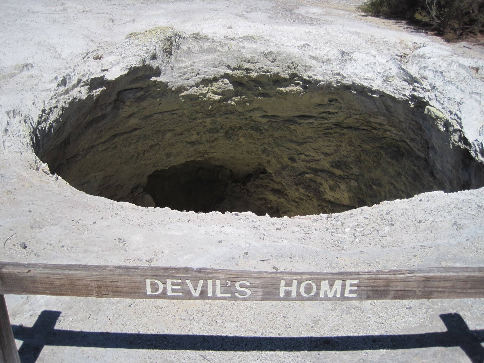
Devil's Home not only looked like it, but sounded like it too.
Not the moon or a black and white photo - but it looks like it doesn't it?

Boiling mud

A river of mud that isn't moving. I thought this was cool and eerie looking at the same time.

"Opal Pool" - for its color of course

The orange shelf sits inside of the Champaign Pool.

Sulphur cave - note the yellow on the walls

Volcanic cliffs - felt like the material in the charcoal grill after burning all night.

Yellow Pool. That's water and not lemonade.

The beauty was accompanied by a smell like rotten eggs. You had to suffer through it to see the park. On a positive note, your sinuses were clear at the end of the day.

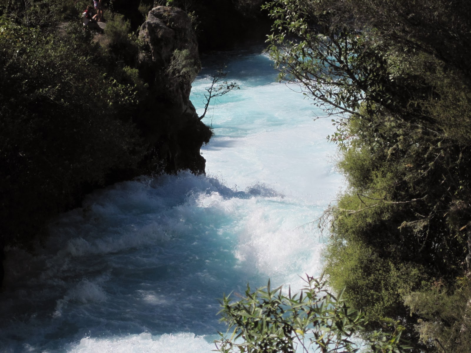
Huka Falls
From Wai-o-tapu we continued our journey to Taupo. We saw this thermo energy plant on the way. No - that's not a nuclear plant - it's thermal energy. Not too many places that have one of these.


Taupo
Our journey that brought us so much beauty on Tuesday was ultimately to get us to Taupo. Taupo sits along the Waikato river at the top of Lake Taupo. This is a huge crater lake right smack in the middle of the North Island of New Zealand. It is New Zealand's largest lake. It covers 238 square miles, and for comparison sake, Lake Tahoe covers 191 square miles and Lake Okeechobee in Florida covers 730 square miles.Taupo is a cute town (about 23K population) that hosts many outdoor activities (hunting, fishing, climbing, boating, etc.). It hosts a huge ironman competition that is expected to go off next week. It is also situated right next to the Tongariro National Park where the Tongariro Alpine Crossing is found. This is one of New Zealand's twelve "Great Walks." Every New Zealander (and tourist) is encouraged to get a sense of the beauty of the country through these fantastic hiking routes. Tongariro Alpine Crossing is the most popular of the Great Walks because it can be accomplished in the day - and some say it may be the most stunning. K and I accomplished this 12 mile hike up and down "Mt. Doom" as it is called yesterday. This is us, at the end of our day on Tuesday on a hill above Taupo. In the other picture, Taupo is in the forefront of the picture, with Lake Taupo behind the city and way off in the distance is the Tongariro Maountin. Yep - we hiked that sucker (bottom to top and down again). More on that trek with my next post.


No comments:
Post a Comment